
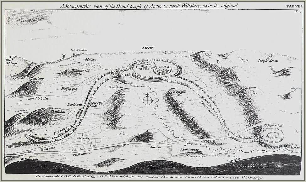
Denis Grant King’s (DGK) journals, written during and after his time spent at Avebury in the 1930s, are rich repositories of names. King notes down site visitors, correspondents, and more. As I’ve been transcribing his journals, I’ve noticed some names appearing frequently, or in contexts which suggest them as important types. I found this fascinating and so decided to do a little research for no other reason than to satisfy my own curiosity. And then I thought, “if I’m interested, other people might be too”; and so here is the first of what is intended to be several occasional nlogs about these people.
I should have come up with some witty heading along the lines of Avebury Additions, or Excavating Extras but alas, I seem to have lost my little pot of inspiration. Maybe you can come up with something suitable? Suggestions in the comments please.
Avebury Visitors: Part One (16 August to 20 August 1938)
Thursday, August 18th 1938
(1732623-001-016). When DGK first arrived at Avebury he had a letter of introduction with him written by OGS Crawford.

Osbert Guy Stanhope Crawford, CBE, FBA, FSA was a man who worked largely as the Archaeological Officer for the Ordnance Survey, plotting the locations of archaeological sites. He specialised in Prehistoric archaeology and wrote many books on the subject. During World War Two, as part of the Royal Berkshire Regiment, he made maps and took photographs of the German positions on the Front Line. In 1927 he founded “Antiquity: A Quarterly Review of Archaeology”, which remains one of THE pre-eminent archaeological journals. The Avebury archive also contains many letters between Crawford and others, including a satirical letter to the Modern Mystic magazine.
Saturday, August 20th 1938
(1732623-001-023). At Woodbury DGK saw an excavation taking place on the crest of a hill in sight of Salisbury Cathedral (these excavations would later be called “Woodbury I and II”). Here he was introduced to Charles William Phillips who was the Hon Secretary of the Prehistoric Society, and a tutor or professor at Oxford, who was in Salisbury on vacation.

DGK describes Phillips as “a fine tall Saxon type, with the muscles of a navvy, aged perhaps 45, with small — almost immature — moustache, and brown to fairish hair”. CWP was also an archaeologist who led the 1939 excavation of Sutton Hoo, and in 1946 replaced OGS Crawford as the Archaeology Officer for the Ordnance Survey.

(1732623-001-023). While at the above-mentioned Woodbury excavations, DGK was also introduced to Dr Gerhard Bersu of Frankfurt and his wife Maria (although DGK never mentioned Maria by name). They were a German couple who had left Germany on account of Gerhard’s Jewish heritage (on the maternal side). DGK describes him as presenting a very comical figure, short and dumpy, round moon-like face, very genial, somewhat discoloured teeth, blue eyes and brownish hair; dressed in loose sail-cloth trousers to the middle caff, a coat of weaving not generally seen in seen in England, and an old greenish Homberg with feathers and heather stuck in the band at the back.
DGK notes that Gehard “spoke in peculiar broken English”, and gives the example of what Gehard was calling “rocking seats” were actually “working seats”. What DGK seemed to be unaware of was Dr Bersu’s ingenious ability to interpret archaeological features. Far from being a ‘dumpy man in strange clothes and an old hat’, the revolutionary excavation techniques employed at this excavation by Gerhard that changed the way Iron Age Britain was interpreted. Before Dr Bersu’s arrival, it was common belief that Iron Age people lived in pits (as DGK mentions in his journal entries). However, by proving that these pits were not dwellings but had been dug for food storage, Dr Bersu was able to prove that Iron Age people lived in Round Houses.
While Dr Bersu was conducting DGK over the site, their group was approached by Lieutenant Colonel Charles Douglas Drew, the curator of Dorset County Museum (DGK mistakenly refers to this as “Dorchester Museum”) and the Secretary to the Dorset Natural History and Archaeology Society. When he died in 1956 The Drew Trust was set up in his name. Even today, this Trust gives outstanding A-Level History students prize money if they attend university.

(1732623-001-026). This entry, a continuation of the 20th August, doesn’t include anyone famous, but it shines a little light onto William Young’s life, and his family’s political interests. William is in charge of the excavations at Avebury and DGK is finishing the day by visiting Mr Young’s family home where he meets Mr Young, senior. On the sideboard he sees two newspapers: The Daily Herald and “Action”. You’re probably wondering why this is worth noting? In those days, The Daily Herald was seen as a newspaper that supported the Labour Party and was aimed at the “working man”. However, Action was a newspaper published by Oswald Mosely’s British Union of Fascists. We don’t know yet what Young senior’s political leanings were, but it raises interesting questions about the circulation of ideas across the country at the time.
Denis was a busy guy on 20th August 1938. I wonder how often he looked back over his diaries and remembered the people he met?
