In the archive, we have several photo albums for the 1934 to 1939 excavations at Avebury. Each album shows us how Alexander Keiller and his team carefully excavated and lifted the stones in the outer circle and down West Kennet Avenue.
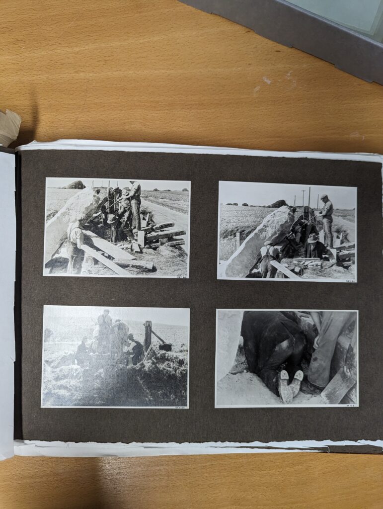
Page 70 in photo album B (78510301_070)
Alexander Keiller was very particular about which photo prints he used in the albums so we have a lot of loose spare prints that did not make the cut.
This means that we have to individually check each print to see if it is a duplicate or an original. To do this we have a quick and easy process.
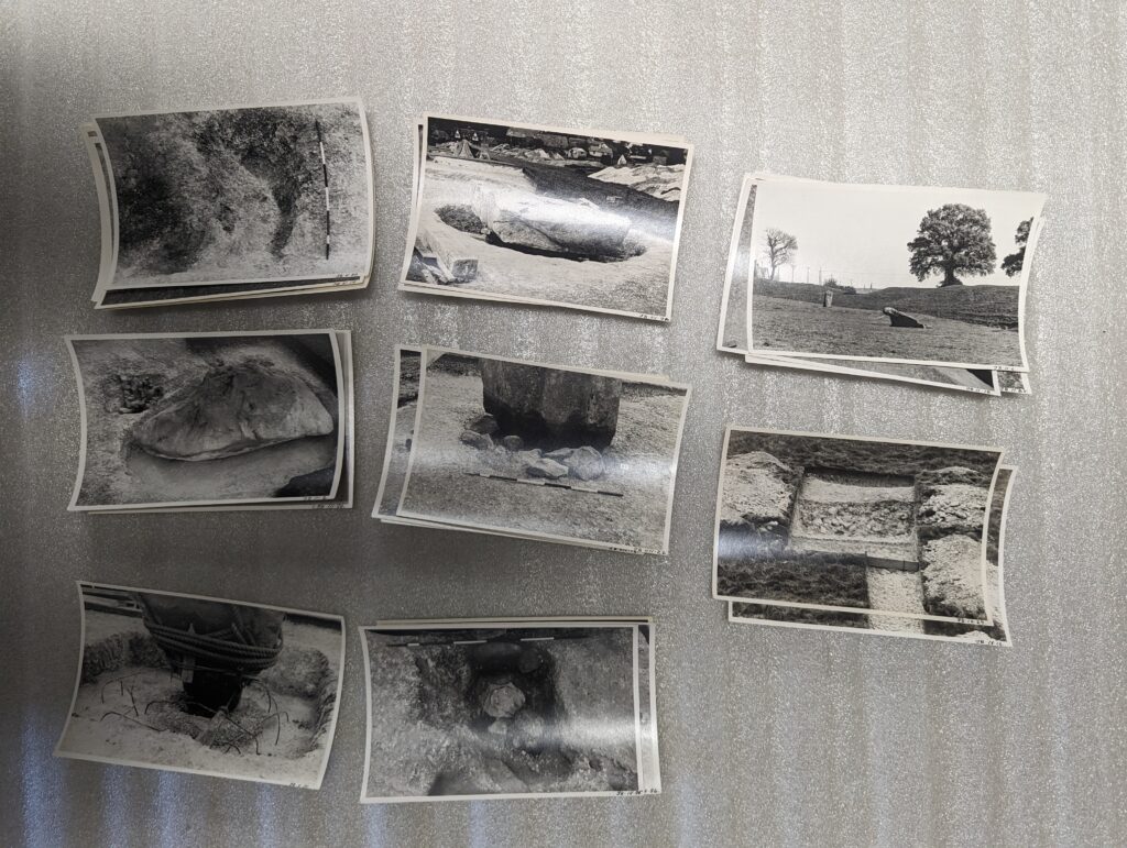
First, we start by dividing the prints into piles. We separate the prints by their film reel number, which Alexander Keiller wrote in the bottom right corner of the print.
Loose prints for photo album G sorted by film reel
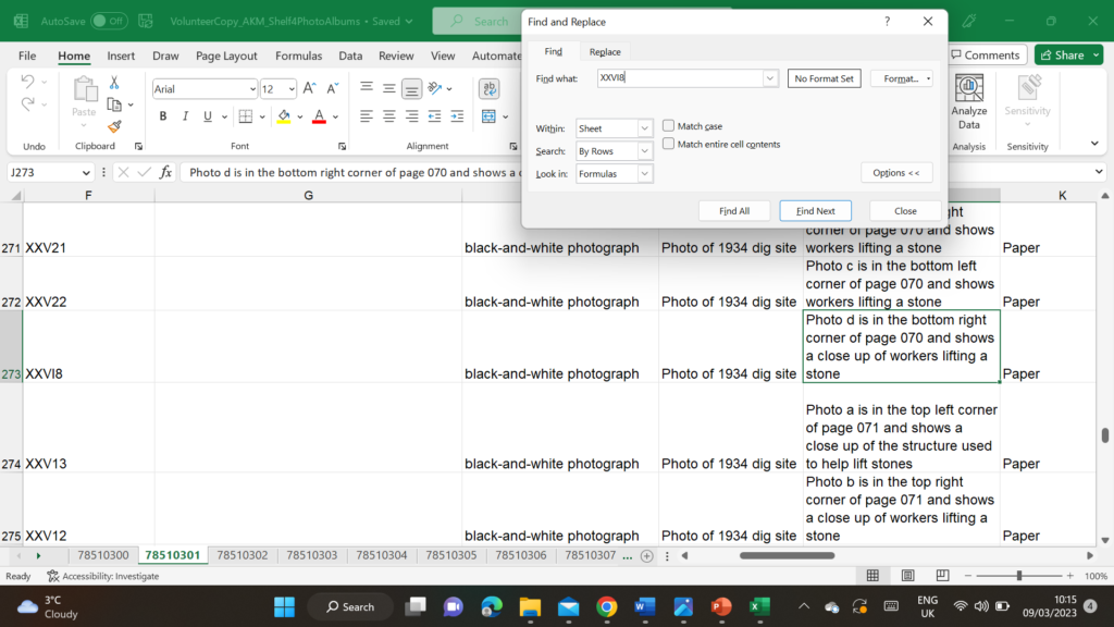
Once sorted we search our excel catalogue to check if any of the prints are already in the album.
searching film numbers on the spreadsheet
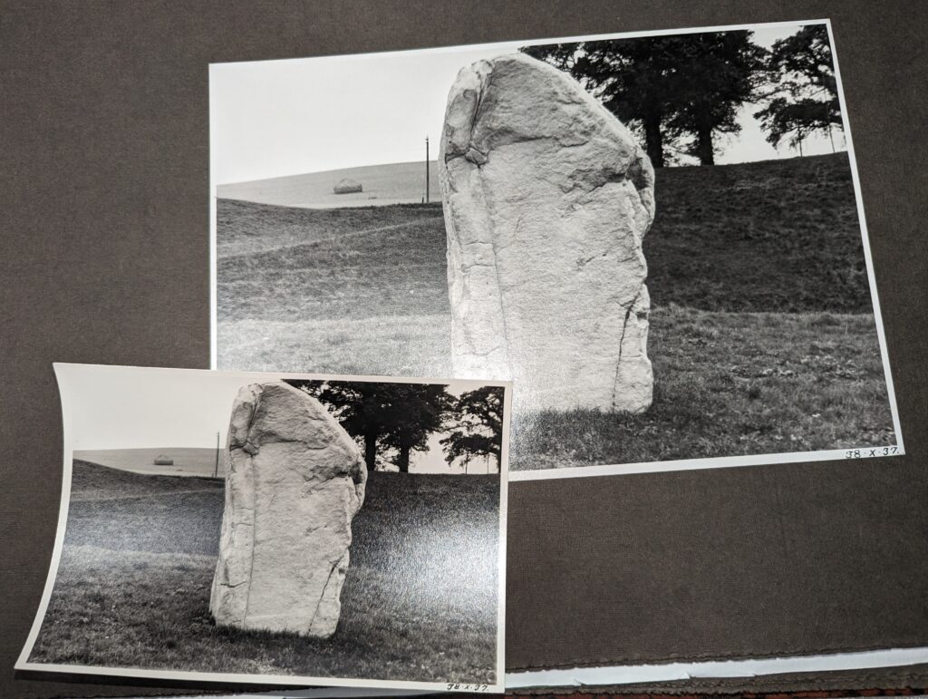
Occasionally we will find that one of the loose prints is already in the album. In this case, we open the photo album to check if the image is the same in the print as it is in the album.
Loose print and Photo Album G (78510306)
Loose prints that are identical to the photo album are separated out from those that are not. This is because we only want to photograph prints that are not already in the albums.
Once a box is sorted into photos already in the album and those that are not it is put back on the shelf to be photographed later.
We are two short months into the digitisation here at Avebury! Below you can watch a very short video going over what we’ve been up to with the volunteer team in the paper archive so far. This video was originally made for the local National Trust spring update.
Please leave your questions or comments – we’d love to know what you think.
We are now well into our second month of digitisation here at Avebury. So let’s look at some cool finds we’ve had this month.
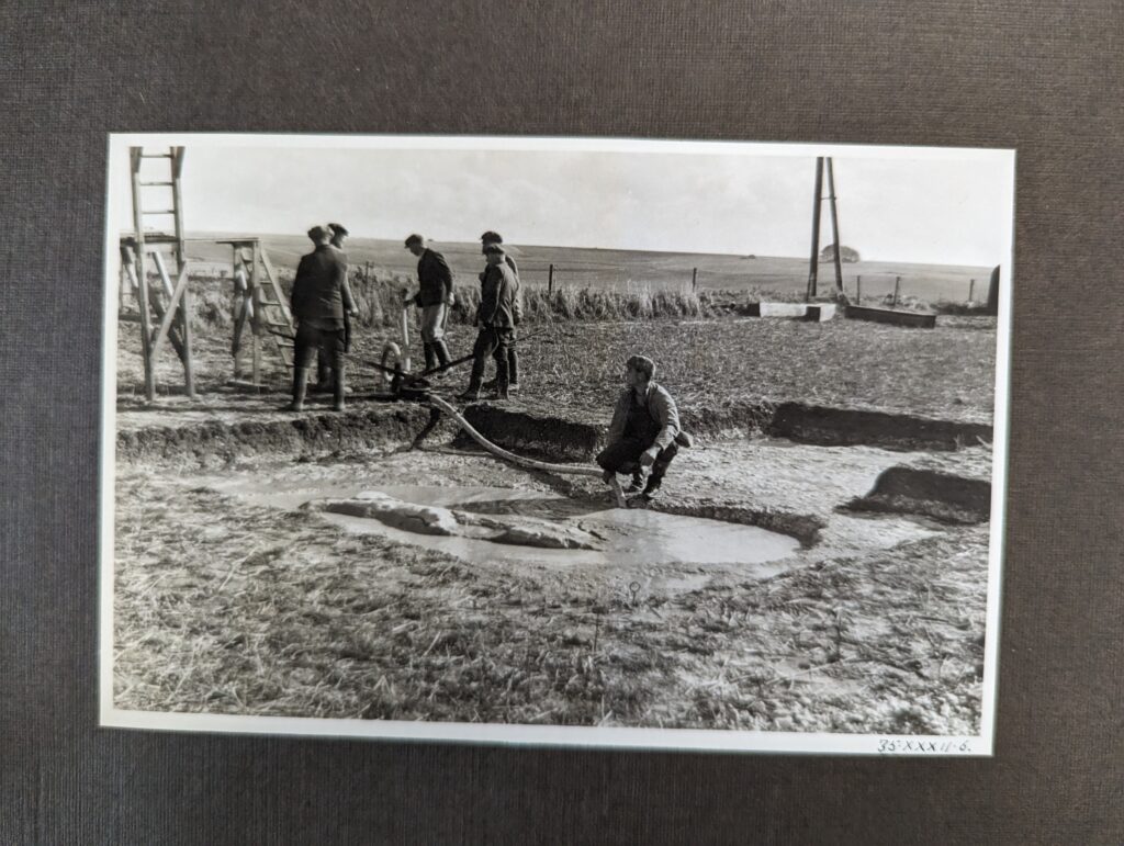
Workers pumping water out of a trench. Photo Album E, page 33, 78510304.
This photo found in photo album E shows workers pumping water out of a stone hole, presumably after heavy rainfall, to complete the stone’s excavation.
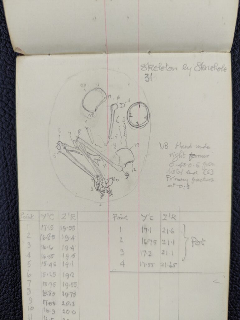
Sketch of skeletal remains in stone hole 31. Found in one of Stuart Piggott’s books, accession number 78510489_059.
This cool sketch was found in one of Stuart Piggott’s plotting books. It shows a detailed drawing of the burial in stone hole 31. Stone hole 31 is the feature that we saw Stuart excavating a pot in last time!
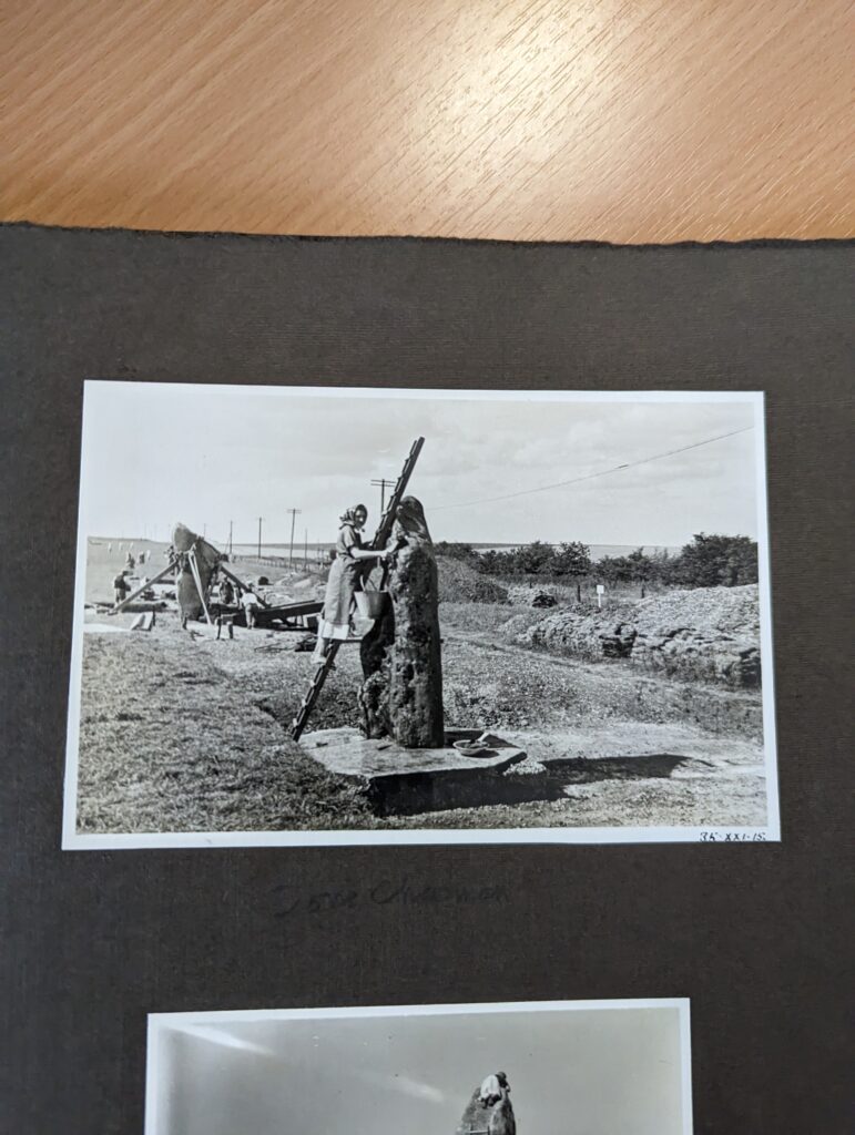
Photo of Doris Chapman cleaning a stone, accession number 78510304_052_b.
The above photo shows worker Doris Chapman up a ladder cleaning one of the excavated and lifted standing stones down West Kennet Avenue. It shows that Alexander Keiller and his team had a sharp eye for the fine details of the site.
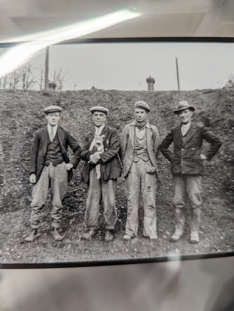
Photo by W E V Young, 1939, accession number 20004235_002.
These workers seem to have found a furry friend on the dig site! This moment was captured by W E V Young in 1939.
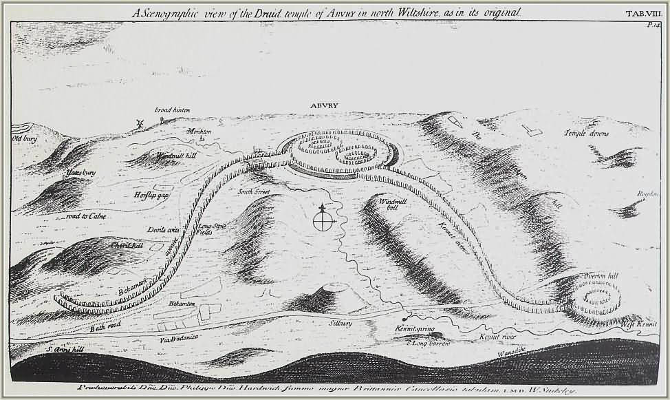
If the West Kennet Avenue had followed a largely straight line (as John Aubrey portrayed it in a drawing carried out shortly after his survey in September 1663), Keiller’s 80’ wide corridor would have done the job. Unfortunately its course was rather sinuous (hats off to William Stukeley) as indicated by a single surviving stone (Keiller’s #34, Smith’s 21A) on the other side of the road running along the eastern edge of the field.
Stukeley’s interpretation of the Avebury landscape, via Wikicommons.
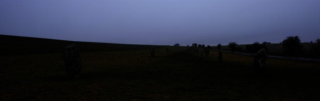
As a result Keiller knew that sooner or later his corridor of regular blocks and cuttings would have to pivot. This eventually came at a distance of just over 243m (800’) from the fence marking the southern end of the field, though it was clear from about 180m that the line of paired standing stones was drifting to the east of the corridor axis. This in turn prompted some nimble footwork (tapework?) on the part of Keiller to modify and extend his cuttings – more about these in a later post.
You can get a sense of the drift from the photograph below I took from the midpoint of the avenue on the southern boundary fence looking northwards towards Avebury.
Looking North towards Avebury through West Kennet Avenue.
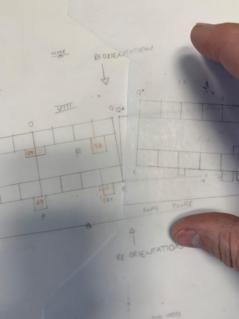
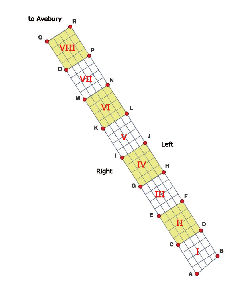
So, using point R as the pivot (marking the 800’ point and north-eastern corner of block VIII – check out the sketch in post #3), he tilted the axis of the entire grid 6 degrees to the east. And then carried on.
Never missing a chance to repurpose a unique identifier, the original north-west corner of block VIII (point Q) was replaced by point Q* precisely 2.499m (8.2’) away. The corridor then trundled on until it met the boundary of the field long its northern edge, slowly intersecting the fenceline on the east as it did so. And that was essentially that.
Pivotting and plotting.
As a visual thinker, the plotting out by hand of the cuttings has proven invaluable in helping me to make sense of the complex textual descriptions and step-by-step annotated drawings in Keiller’s Plotting book. I now understand better not only what he had done, but how he went about doing it.
The next step will be to replicate this digitally in the GIS. The first stage in that process is going to be identifying points on the digital ground today (i.e. the Ordnance Survey map coverage) that correspond to points established in 1934 by Keiller. More of that in the next post.
I have a confession. Much as I admire his surveying chops, Keiller’s approach to numbering and labelling (stones, cuttings, whatever) leaves me sobbing.
Let me give you a flavour of what I mean. In an earlier post I mentioned that he liked to re-use letter codes for reference points and survey datums/stations. Taking 1934 as an example, ‘A’ and ‘B’ could refer to the mid and end point of the original line he surveyed running across the axis of the Avenue line or the points where the baselines bounding his 80’ wide corridor intersected the fence at the southernmost end of Mr. Peake-Garland’s Waden Hill Field. Take a look at the drawing below from the plotting book and you will see what I mean.
Where the survey blocks met the southernmost fence line crossing the field
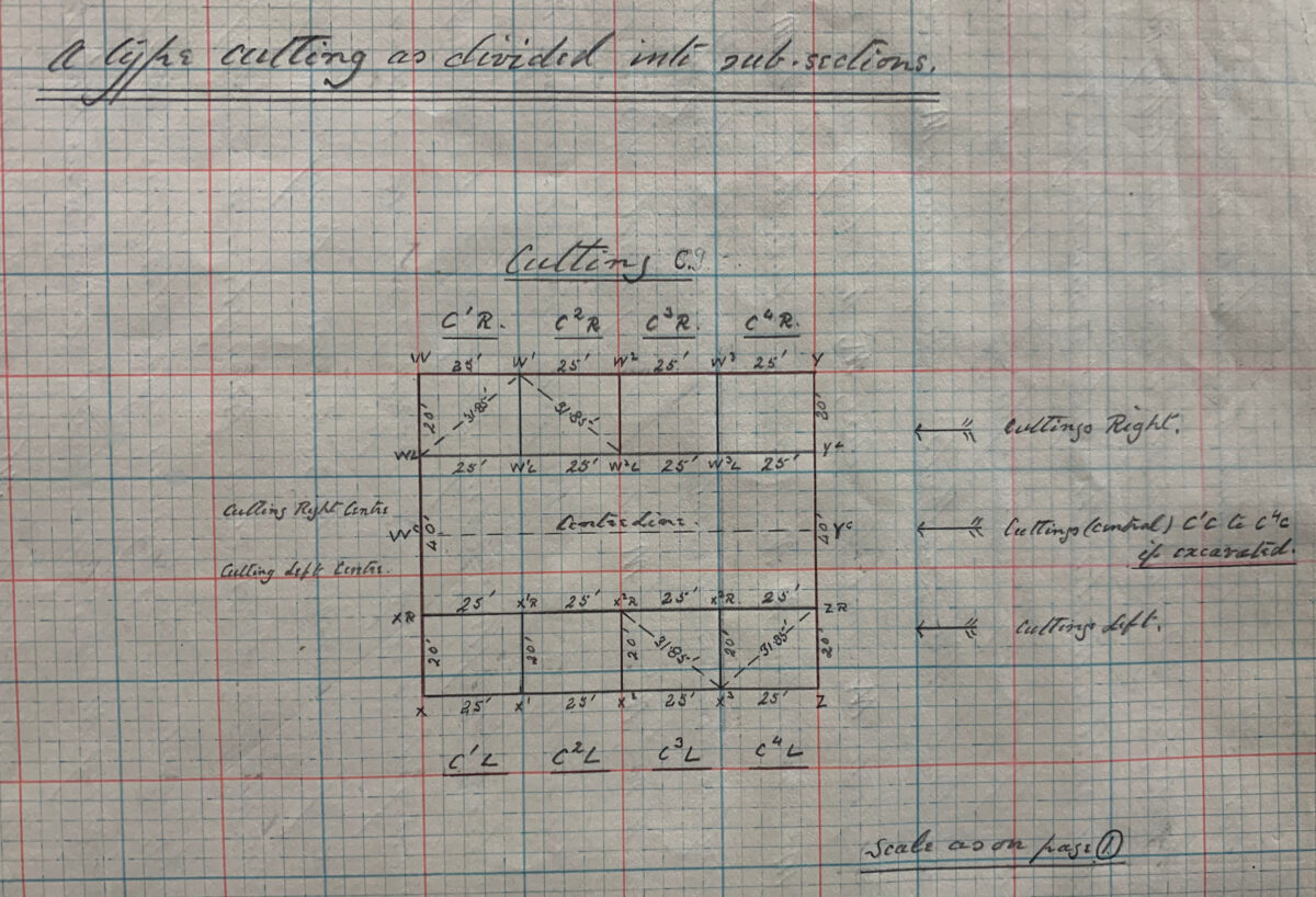
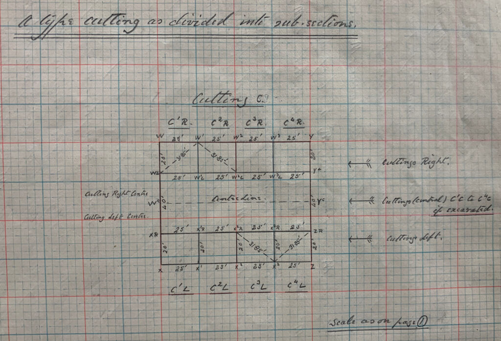
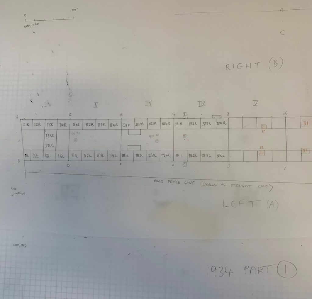
But the real fun has yet to start. He numbered his individual 100 x 80’ survey blocks from south to north, using Roman numerals – I, II, III, IV etc… Each of these blocks in turn contained a total of sixteen 25 x 20’ sub-cuttings – four rows of four. The individual sub-cuttings were given Arabic numbers – also incrementing from south to north – and always indicated in superscript. To differentiate between the two rows of cuttings that ran up either side of the line of 100 x 80’ blocks – i.e. that theoretically tracked the lines of paired megaliths – he used L (Left) and R (Right). However, in deciding which side was Right and which Left, instead of facing north towards Avebury, he faced South, away from it. So… the 3rd cutting of the fourth block on the western side of the Avenue would be sub-cutting IV3R. Its partner on the eastern side would be IV3L. As for the two rows of 25 x 20’ cuttings running down the centre of the Avenue line Keiller added a C to indicate that a given code referred to a central sub-cutting (e.g IV3RC and IV3LC). It was so overwrought that the plotting book included a dedicated diagram to demystify it (see below).
The key to Keiller’s labelling schema
And it gets worse. Keiller gave the corners of each 100 x 80’ block a letter code, moving up through the alphabet from south to north. The diagram I have sketched out below should hopefully clarify.
codes and datums everywhere
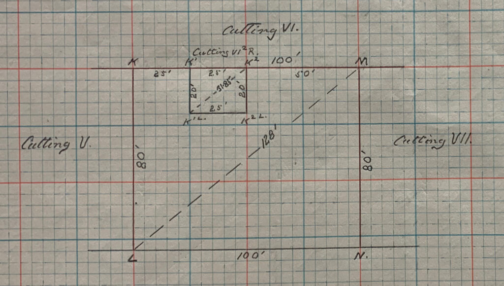
In his descriptions and in plotting book diagrams, the corners of the subdivisions of the cuttings are labelled with respect to these corner designations. So the 2nd sub-cutting on the ‘Right’ hand side of block VI would be designated VI2R and its corner points (moving clockwise) K1, K2, K2L and K1L. Take a look at the subdivision plan below (more on subdivisions and extensions in the next post) and you will get a sense of the complexity that is piling up – and this is just in laying out the trenches.
labelling the sub-cuttings
My final note on the coding relates to the individual standing stones themselves. Here Keiller took a refreshingly simple approach. Each megalith had its own number, starting at the southern extent of his excavation area with standing stone 1 and then incrementing as he moved northwards towards Avebury. So, the southernmost stone pair in Waden Hill Field = stones 1 and 2. The next pair to the north 3 and 4, and so on. Odd numbers on the Right (western) side, even numbers on the Left (eastern) side.
When Isobel Smith produced her synthetic publication of the Avenue excavations, she renumbered. Instead of individual megaliths, she numbered stone pairs (using A to indicate Left and B to indicate Right). She also flipped the numbering strategy on its head, starting at Avebury with Pair 1 and incrementing as one moves south. The logic was faultless: there were undoubtedly more stones waiting to be discovered to the south of Keiller’s Pair 1 and 2, and her approach allowed meaningful numbers to be assigned to them. Irony is in the eye of the beholder, but for me it did add a layer of complexity to what was probably Keiller’s least torturous schema.
That’s me done for now. In the next post we will look at what Keiller did when things did not go to plan (no pun intended).
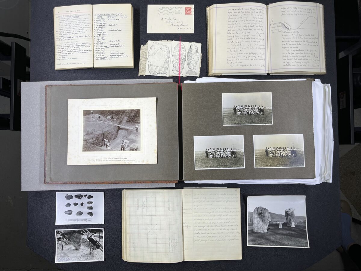
A selection of items from the Alexander Keiller Museum archive.
Choosing a photograph for the homepage of this website was tricky. We wanted something that would represent a wide selection of items held at the Alexander Keiller Museum, while taking conservation requirements into account.
So, while we couldn’t mix paper and artefacts, we went for a selection of photographic prints, letters, diaries, and archaeological drawings.
Here’s what you can see on the Avebury Papers homepage, starting from the top left item working across, with further details about each item…
aveburypapers.org home page flat lay with numbers.
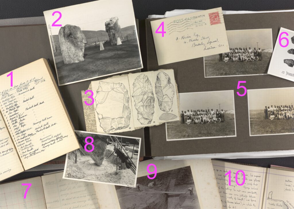
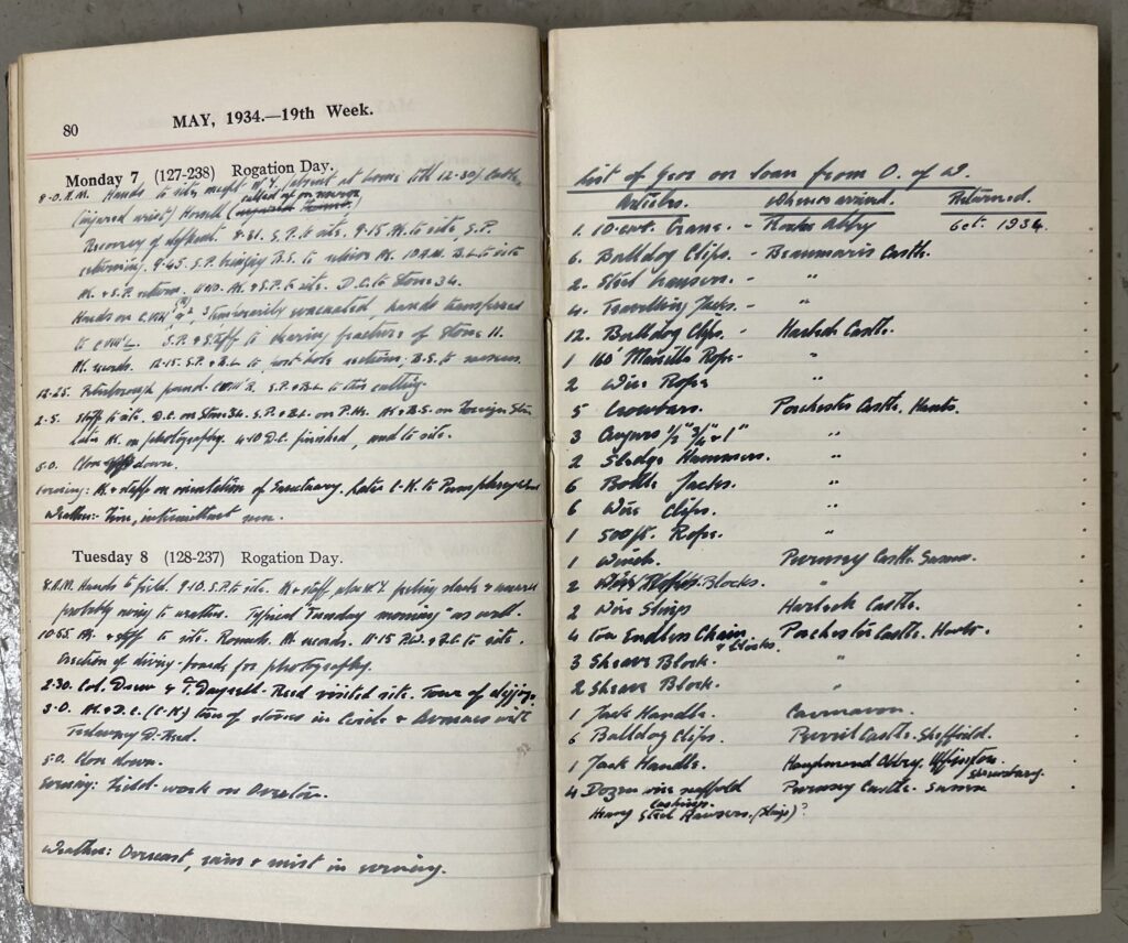
1. West Kennet Avenue Excavation Diary, 1934, accession number 78510467. Alexander Keiller and his team kept meticulous records during their excavations. We wanted to show an example of Keiller’s handwriting, and here we’ve opened the diary at a spread which shows a day entry on the left, and a list of gear loaned from ‘O of W’ (Office of Works) on the right. By the end of this project, handwritten diaries will be transcribed and searchable.
West Kennet Avenue Excavation Diary, 1934, accession number 78510467.
2. A black and white print from 1939 of two standing stones, and two newly installed ‘obelisks’ to mark lost stones, with an early 20th century photograph number 39II24.
3. Three pen-and-ink drawings of flints, possibly made by H G O Kendall at Grimes Graves. These three drawings are pasted onto newspaper, and there are 84 such collages that are collectively accessioned to 88051603.
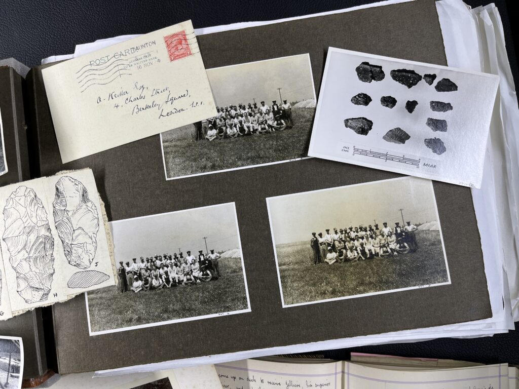
4. A postcard addressed to Alexander Keiller’s Berkeley Square home, with a postmark of 16 November 1924, accessioned with letters to Keiller at 78510455.
5. Photo Album A, open at page ‘000’, showing the West Kennet Avenue staff team in 1934, accession number 78510300. A key aim of the Avebury Papers is to identify these people and gather biographical information. Do you recognise anyone?
6. A photographic print of a flat lay of pottery dated to 1939, and accessioned with an early 20th century photograph number 39IV5. The letters ‘MIAR’ in the bottom right of this image stand for Morven Institute of Archaeological Research, the business that Keiller established for carrying out his archaeological activities.
Various items from the Alexander Keiller Museum archive.
7. The 1934 West Kennet Avenue excavations plotting book, accession number 78510469. The book is open at a spread showing – in very faint pencil – Keiller’s record of ‘Cutting XXI’. Today, we’d call a ‘cutting’ a ‘trench’. Keiller was idiosyncratic in how he extended trenches, sometimes adding ‘squares, rectangles, or parallelograms of extension’. In order to accurately map Keiller’s measurements onto a precise location, Mark has his work cut out translating imperial and analogue to digital and metric! You can read more about this activity in Mark’s blog series.
8. A stone supported by ropes and props, waiting for concrete to be poured at the base. The excavation staff devised pulley systems to support the megaliths as they were heaved from the ground and re-erected. This photo is dated to 1938, and accessioned with an early 20th century photograph number 38VIII24.
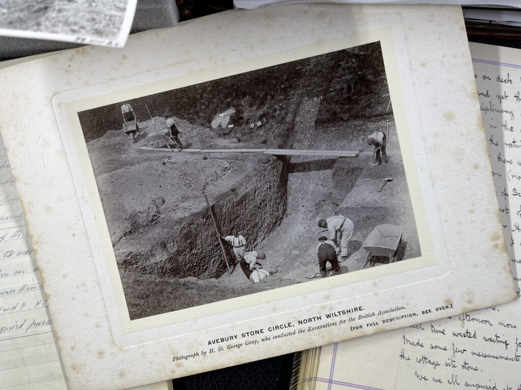
9. Workers excavating the ditch at Avebury, directed by Harold St George Gray for the British Association. The photograph was possibly taken by Gray, and is dated to 1908, with the accession number AVBAKP10.
Workers at Avebury in 1908, accession number AVBAKP10.
10. Denis Grant King diary from Wednesday 31 August 1938, accession number 20001093. Grant King kept beautifully illustrated diaries, which add detail to 1930s Avebury. He was an accomplished archaeological draftsman, and his plans, sections, and drawings from the 1930s further make up a meticulous record of the excavations and findings.
Denis Grant King diary, showing the entry for Wednesday 31 August 1938, Alexander Keiller Museum accession number 20001093.
Next step is to recreate Keiller’s excavation grid using the step-by-step measurements and drawings in his 1934-5 Plotting Book. I could have taken a digital approach from the outset, but to limber up, and better understand how the grid of planned excavation cuttings slowly unfolded on the 10th of April 1934, I began by hand-plotting his measurements, to scale, on a sheet of drawing film.
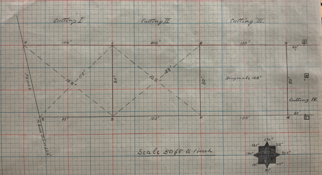
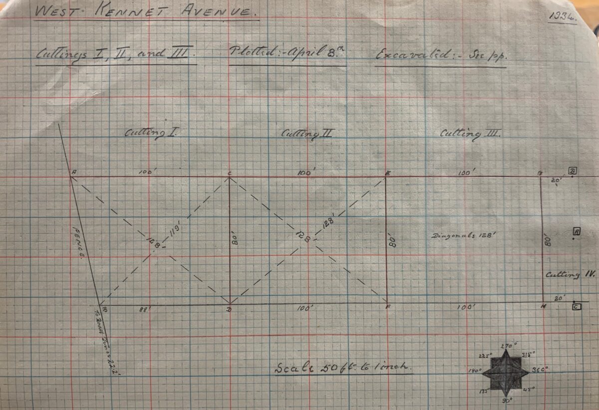
It all began for Keiller with the setting up of a point on the central axis of the Avenue line. The focus of the 1934 excavation was Mr. Peake-Garland’s main Waden Hill field; a strip running north-south alongside the road linking Avebury to West Kennett. Keiller started by establishing a centre line along the main axis of the Avenue at the southernmost end of the field, where 11 surviving stones could be seen (9 fallen and 2 still standing as a pair). He used a tape to measure the midpoint between the southernmost duo of fallen stones (37A and 37B using Smith’s numbering scheme) and did the same between the surviving upright stones 33A and 33B. He then joined the dots to create a notional line running down the centre of the Avenue and established a reference point (labelled A) on this line.
Keiller’s cuttings 1, 2, and 3, showing points A, B, C, D, E, F, G and H along West Kennet Avenue. A page from the 1934 plotting book, accession number 78510469 at the Alexander Keiller Museum.
Using a theodolite the next step was to set out two points perpendicular to A and at a distance of 40’ (12.19m) to the approximate east (C) and west (B) respectively. These points marked the east and westernmost extensions of the grid needed to encompass the width of the Avenue line. So far so good. Using this line of 3 points as a reference, Keiller then set out an 80’ (24.38m) wide corridor running to the northwest towards Avebury. This corridor was subdivided along its length into a series of numbered 100’ x 80’ (30.48 x 24.38m) blocks which were in turn subdivided into parallel lines of 25’ by 20’ (7.62 x 6.09m) cuttings designed to capture the locations of Avenue stones (more on the rather idiosyncratic coding of these blocks and sub-divisions in the next post).
What Keiller and his team had achieved with a theodolite and 100’ survey chains, I was mirroring using a sharp pencil, drawing film and graph paper; working page by page through the plotting book…
Stuart Piggott working on some pottery in a feature, from Photo Album B, West Kennet Avenue excavations 1934, accession number 78510301, Alexander Keiller Museum.
This month we had the first volunteers in the archive, here are some of the cool things they found in the photo albums photographed so far.
Workers setting up lifting equipment: a man stands on a ladder supported by the field hands team. From Photo Album A, Avenue excavations 1934, 78510300, Alexander Kellier Museum.Workers setting up lifting equipment. From Photo Album A, Avenue excavations 1934, 78510300, Alexander Kellier Museum.
The photos above show workers setting up a pulley system to help lift one of the stones into place in the West Kennet Avenue excavations. This clearly shows that there was no such thing as health and safety back in the 1930s.
Workers on a break around a caravan, Album C, West Kennet Avenue excavations 1935, 78510302, Alexander Keiller Museum.
Not everything was all hard work on the Keiller excavations, workers had the chance to take breaks and relax in the summer sun. They even had a caravan!
A toy armadillo on a stone, Album A, Avenue excavations 1934, 78510300, Alexander Kellier Museum.
Keiller and his excavation team were known to hide a toy armadillo around the dig site. Here is one example we found this week.
Stuart Piggott working on some pottery in a feature, from Photo Album B, West Kennet Avenue excavations 1934, accession number 78510301, Alexander Keiller Museum.
In the above photo, it looks like archaeologist Stuart Piggott is having an afternoon nap in a feature. However, upon further inspection, you can tell he is carefully removing soil from around the base of a fragile piece of pottery.
Photograph of a page from Keiller's 1934-5 West Kennet Avenue Plotting Book, accession number 78510469, Alexander Keiller Museum. The plotting book is made with graph paper, and on this page are plan drawings of cuttings, or 'trenches', by Keiller, showing measurements.
One of the most vexing challenges in relation to the Keiller excavation archive relates to the precise locations of the trenches his team excavated – what he termed ‘cuttings’. One of the goals of the project is to create a series of georeferenced digital trench plans for each of the years of excavation. As to why, once in place these will enable us to spatially locate and anchor the various finds uncovered, photographs taken and pithy asides scribbled in the dig records and diaries.
We certainly have the re-erected stones and concrete markers resulting from the excavation trenches, but as to the precise areas that were investigated around these we are in the dark. As for the published trench plans, experience from previous attempts to fix these to the current Ordnance Survey base mapping for the area revealed significant levels of artistic licence and generalisation that precluded any neat fit.
As a result, the decision was taken to go back to Keiller’s original survey records and start from scratch – using the digital equivalent of 100’ survey chains and theodolites in order to lay out his trenches afresh. This meant working methodically through the 1934-5 Plotting Book which contains highly detailed scale drawings alongside a narrative account of the work carried out. More of this to come in later blogposts, but a number of issues rapidly became clear.
First, Keiller was a confident and accomplished surveyor, and you can very quickly see why his surveying skills earned the respect of Mortimer Wheeler.
Second, he was obsessive with regard to formality and precision – rectangles, triangles and parallelograms abound. If a cutting needed to be extended to capture the full extent of a feature, it was not enough to simply extend until the feature had been revealed (and then tidy up and record the resultant extension). Oh no. Instead meticulously surveyed extensions were laid out in order to facilitate this search, and if the full extent was not revealed a second stage of meticulous survey was carried out to further extend.
Third, and building upon the point above, for Keiller the laying out of trenches was an end in itself (meticulously surveyed and geometrically perfect) rather than a means to an end (a framework for the excavation).
Fourth, for all of the above he was remarkably lax in some regards. For example, the baselines setup in 1934 to lay out the cuttings along the line of the West Kennet Avenue were basically floating. They were established in relation to extant pairs of stones that were not themselves surveyed in position prior to the survey. Needless to say these stones were subsequently relocated and set into concrete as a consequence of the excavation and restoration work. He also had a habit of re-using codes to indicate reference points on his cutting grid.
So, with pencil, permatrace, mouse and GIS in hand, it was time to go back to early April 1934 and begin to follow Keiller in laying out the first of the Avebury cuttings….
Dr Colleen Morgan was interviewed by Ellie Brennan on BBC Radio York on Friday 23 January. Listen to the clip below.
Transcript
Ellie Brennan:
Now, from dissertations and homework, to a very serious and amazing project going on to do with a world-famous stone circle. It’s going to be brought to life online for the first time. Experts from the University of York are involved in the work to digitise the archives about the Avebury stone circle in Wiltshire, and they’re going to make them available to the public.
And with me now is Dr Colleen Morgan, who is from the Department of Archaeology at the University of York. Morning, Colleen.
Colleen Morgan:
Oh, so nice to join you, Ellie, thanks for the welcome.
Ellie Brennan:
Thank you for coming on and talking to us about this, it sounds amazing, For people that don’t know, can you describe the Avebury site for us? How significant is it?
Colleen Morgan:
Oh, it’s very significant, it’s a key component of the UNESCO Stonehenge and Avebury World Heritage Site, and it’s actually the largest stone circle in the world.
And I think people are really personally very invested in this site, It is from the Neolithic, but unlike Stonehenge, you can actually go up and touch the stones.
Ellie Brennan:
Oh, my goodness, I was just going to ask you about this, because Stonehenge, I feel like, gets all the glory here. I had no idea that Avebury was the biggest.
Colleen Morgan:
Yes, absolutely, and it’s just a fantastic opportunity to investigate this really important archive that has been hereto really inaccessible.
It’s in the middle of the monument, so you have to actually go there, and it’s really difficult to access even if you are there. And it’s really interesting to be there because there’s not a lot of phone signal, the internet is not very good, and so it really is revealing this world-class archive to the entire world.
Ellie Brennan:
So that’s why it’s important to digitise, more people are going to have access to it.
What’s the most interesting thing you’ve discovered in the archives? And what might we be able to see in the future?
Colleen Morgan:
I think for me, personally, it’s actually seeing the faces of the old excavators: there were a lot of excavations in the 1930s headed by Alexander Keiller, he’s the major player, but we don’t know the personalities of the people involved.
But we’re also doing a full analysis of all the material that’s ever been excavated there at Avebury as well: Ben Chan from Bournemouth is working on this, and so we’re really excited to do the more scientific techniques that we’ve developed since the 1930s on this really important archive.
Ellie Brennan:
How significant is this archive for you in terms of history?
Colleen Morgan:
Well, it’s got 13,350 pages of documentation, it’s got 500 drawings and 3000 images, much of which have just been under used to a certain extent. They did a similar project at Stonehenge a few years ago under the same curator, the amazing Ros Cleal, and they were able to herald a new programme of research at Stonehenge and so we’re hoping the same revival comes to Avebury as well.
Ellie Brennan:
You’ve just mentioned there over 13,000 documents, 3000 pictures, how long is it going to take to digitise this? Because that sounds like an awful lot of scanning in.
Colleen Morgan:
Oh absolutely! And so there’s a fantastic researcher down there right now, Fran Allfrey, and she’s been working really hard to scope the archive. It is going to be finished in the four years that we have on the project, but we are also enlisting many, many volunteers down in Wiltshire.
But the exciting thing is that after we digitise things, we’re going to need the help of online volunteers to actually do a lot of the transcription because Alexander Keiller has the worst handwriting I’ve almost ever seen in an archive, and so it’s going to take a lot of puzzling out.
Ellie Brennan:
Okay, so if you think you’re good at reading handwriting, you’re needed: is that the call out here?
Colleen Morgan:
Absolutely! And there’s just going to be so much there and so much available, and it’s going to be available through the Archaeology Data Service, which we are really lucky to have here at York because it is, again, a globally known digital archive for archaeology that is freely available online for people to go and root through the past.
Ellie Brennan:
That sounds absolutely incredible. I mean, if people would like to volunteer and get involved with this when it is going online, how can people find information about this, Colleen?
Colleen Morgan:
www.averypapers.org
Ellie Brennan:
Fantastic. Well, it sounds like a mammoth project and so interesting, thank you so much for coming on to talk to me about it today. That’s Dr Colleen Morgan who’s from the Department of Archaeology at the University of York, who I think will be doing a lot of scanning over the next few months, of all the archives about the Avebury stone circle in Wiltshire.
I had absolutely no idea that was bigger than Stonehenge: every day truly is a school day isn’t it!


