This blog post is part of a series: read Part 1 here, and read Part 2 here.
I have a confession. Much as I admire his surveying chops, Keiller’s approach to numbering and labelling (stones, cuttings, whatever) leaves me sobbing.
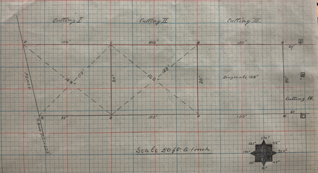
Let me give you a flavour of what I mean. In an earlier post I mentioned that he liked to re-use letter codes for reference points and survey datums/stations. Taking 1934 as an example, ‘A’ and ‘B’ could refer to the mid and end point of the original line he surveyed running across the axis of the Avenue line or the points where the baselines bounding his 80’ wide corridor intersected the fence at the southernmost end of Mr. Peake-Garland’s Waden Hill Field. Take a look at the drawing below from the plotting book and you will see what I mean.
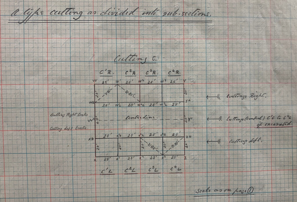
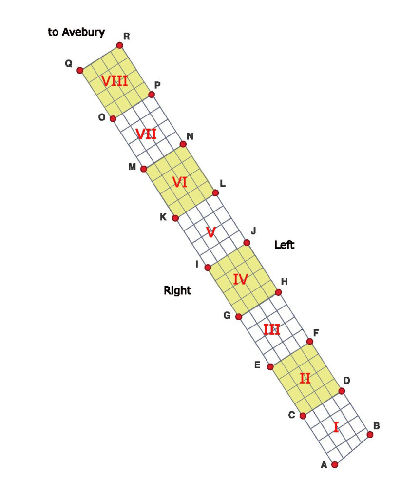
But the real fun has yet to start. He numbered his individual 100 x 80’ survey blocks from south to north, using Roman numerals – I, II, III, IV etc… Each of these blocks in turn contained a total of sixteen 25 x 20’ sub-cuttings – four rows of four. The individual sub-cuttings were given Arabic numbers – also incrementing from south to north – and always indicated in superscript. To differentiate between the two rows of cuttings that ran up either side of the line of 100 x 80’ blocks – i.e. that theoretically tracked the lines of paired megaliths – he used L (Left) and R (Right). However, in deciding which side was Right and which Left, instead of facing north towards Avebury, he faced South, away from it. So… the 3rd cutting of the fourth block on the western side of the Avenue would be sub-cutting IV3R. Its partner on the eastern side would be IV3L. As for the two rows of 25 x 20’ cuttings running down the centre of the Avenue line Keiller added a C to indicate that a given code referred to a central sub-cutting (e.g IV3RC and IV3LC). It was so overwrought that the plotting book included a dedicated diagram to demystify it (see below).
And it gets worse. Keiller gave the corners of each 100 x 80’ block a letter code, moving up through the alphabet from south to north. The diagram I have sketched out below should hopefully clarify.
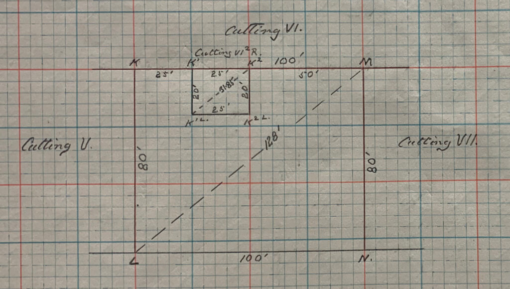
In his descriptions and in plotting book diagrams, the corners of the subdivisions of the cuttings are labelled with respect to these corner designations. So the 2nd sub-cutting on the ‘Right’ hand side of block VI would be designated VI2R and its corner points (moving clockwise) K1, K2, K2L and K1L. Take a look at the subdivision plan below (more on subdivisions and extensions in the next post) and you will get a sense of the complexity that is piling up – and this is just in laying out the trenches.
My final note on the coding relates to the individual standing stones themselves. Here Keiller took a refreshingly simple approach. Each megalith had its own number, starting at the southern extent of his excavation area with standing stone 1 and then incrementing as he moved northwards towards Avebury. So, the southernmost stone pair in Waden Hill Field = stones 1 and 2. The next pair to the north 3 and 4, and so on. Odd numbers on the Right (western) side, even numbers on the Left (eastern) side.
When Isobel Smith produced her synthetic publication of the Avenue excavations, she renumbered. Instead of individual megaliths, she numbered stone pairs (using A to indicate Left and B to indicate Right). She also flipped the numbering strategy on its head, starting at Avebury with Pair 1 and incrementing as one moves south. The logic was faultless: there were undoubtedly more stones waiting to be discovered to the south of Keiller’s Pair 1 and 2, and her approach allowed meaningful numbers to be assigned to them. Irony is in the eye of the beholder, but for me it did add a layer of complexity to what was probably Keiller’s least torturous schema.
That’s me done for now. In the next post we will look at what Keiller did when things did not go to plan (no pun intended).